Temperatures on the rise again
50s later this week!
- Near 40° today
- 50s by Wednesday
- No significant rain/snow chances
Download the First Alert Weather app
MADISON, Wis. (WMTV) - The second half of our weekend is looking much warmer, and the warming trend will continue through most of the upcoming workweek. Temperatures will be climbing back to 15-20° above average by the midpoint of the week - that’s closer to typical April weather!
Our average high temperature for the first half of February was 41.9° which puts us at the second warmest start to the month on record.

What’s Coming Up...
Skies stay clear today, and winds will gradually calm as the day goes on. This morning though, gusts will remain around 20-25 mph out of the west. Temperatures will climb quickly from the 20s this morning to the upper 30s and lower 40s this afternoon.
Mostly clear overnight with lows falling near 20°. A sunny President’s Day on Monday, with temperatures warming even faster through the day. Highs will be in the mid-40s by Monday afternoon with light, southerly winds.


Looking Ahead...
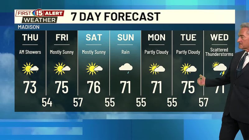
A mostly dry pattern will take shape this week. A small low-pressure system will increase cloudcover on Tuesday, but it will also bring a warm front closer to the region. That will sweep through on Wednesday and will boost our temperatures into the low and middle 50s.
We’ll see a slight dip in temperatures before the next weekend, but all of the next 7-days will stay above the seasonal average.

Click here to download the NBC15 News app or our NBC15 First Alert weather app.
Copyright 2022 WMTV. All rights reserved.